- HOME
- PRODUCTS & SERVICES
GIS/GPS in Smart Cities/Transport METRIS — Big Data in Metro Transportation METRIS LiveQ: Real-time Truck Queues METRIS — Port Performance METRIS — GPS Tracking METRIS — Transport Planning Advanced GIS Analytics/Algorithms Transport Research Error Modeling Conflation GIS in Retail CLEO — Location Optimization Trade Areas Gravity Models Location-Allocation Models Enterprise GIS Strategic plan & cost-benefit analysis GIS Data Modeling
- RESOURCES
News & Commentary METRIS News & Press Reports Light Technical Geography 80-20 (nuggets for adults) Geography Kids' Hangout Technical GIS Publications METRIS Publications Associated projects NCRST VITAL
- ABOUT
Conversational Latitude and Longitude
How to read those gobbledygook numbers on a GPSVal Noronha | The Geography 80-20 collection

GPS reports position in latitude and longitude. Around the turn
of the 21st century, several researchers thought
non-professionals would never be able to fathom lat-long, and
they proposed some improbable alternatives. One scheme expressed
coordinates as alphabets, describing a place as GH8JK QFGSD for
example. Another expressed locations relative to city centers:
LAX146275. These schemes flopped. Ordinary people do seem to
embrace lat-long. But it remains a bit mysterious. Perfect
candidate for 80-20 treatment.
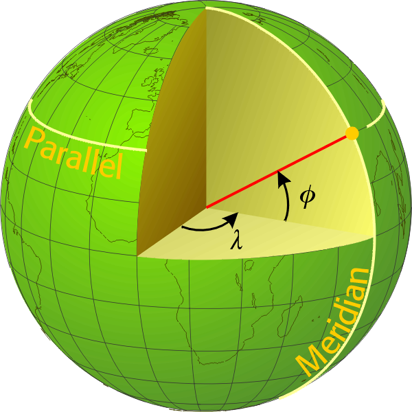
 Here's the
fairly formal definition: The latitude (φ) of a point is the
angle it makes at the center of the earth with the equatorial
plane. In the figure, the point we're talking about is the gold
dot on the earth. Drive a (long) knitting needle through it, to
the center of the earth (the red line), and the angle it makes
with the equatorial plane is the latitude. You'll see why the
equator has a latitude of zero, and the north pole 90°N.
The longitude (λ) of a point is the angle between its meridional plane and the plane of the prime meridian. The meridional plane of the point is the vertical face running through it, with its edge marked “Meridian.” The other (reference) face runs through Greenwich (and Spain and western Africa). You can measure the angle at the equator or at the relevant latitude, it's the same.
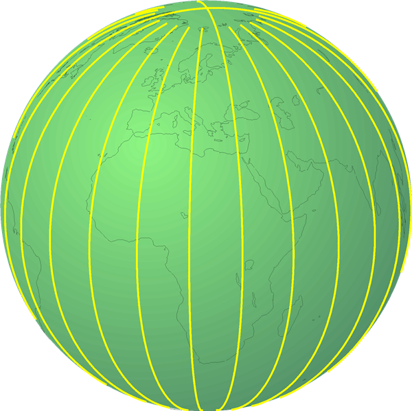
Points with the same latitude form a parallel — think about spinning the earth around while that red knitting needle is held firmly in place at an angle of φ. Points with the same longitude form a meridian — that's what you get when you drop the knitting needle to the equator, down to the south pole and all the way around.
Latitude and longitude are not simply at right angles to each
other, the way x and y are on a graph. Parallels are horizontal, of different sizes,
getting smaller towards the poles, centered at intervals
along the axis . The circles do not meet each other. Meridians, the north-to-south
circles, are all the same size, centered at the center of the
earth; they all converge at the north and south poles.
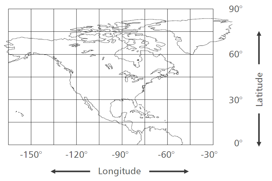
Nonetheless, for many purposes you could think of lat-long as
regular coordinates on normal graph paper, just expressed in reverse order. Latitude is y,
it measures north-south distance; longitude is x, it measures
east-west distance. (Purists may protest, but the fact is that
our world is full of maps built around this simplification.)
Confounding matters a little, west longitude is treated as
negative, as is south latitude. But it's just regular square
graph paper.
 |
+ |  |
= |  |
| Parallels | Meridians | On regular graph paper Not bad, as long as we're aware of the limitations. |
Conversational latitude
Now let's get a feel for the numbers.
Latitude is the number of hours it takes to drive to the equator at freeway speed. Panama, at 10°N, is a 10-hour drive to the equator. For Santa Claus at the North Pole (90°N), it would be a 90-hour drive, which is why he invented a flying sleigh.
Latitude is traditionally expressed in degrees, minutes and second (DMS), but we now tend to prefer decimal degrees (D.DD). 34.352° is easier to say, write and remember than 34° 21' 7.2", and you can run arithmetic on it, adding and subtracting, more easily. But both expressions can be friendly.
Decimal degrees
The fifth decimal place
in latitude is about a meter
(1.1 m actually). So 34.12345°N is
one meter north of 34.12344°N, and 45 meters
north of 34.12300°N. With this
simple rule of thumb, you can translate latitude to distance on
the ground. My dad's house is at 34.4°N, mine is at 34.1°N. That
puts him 30,000 meters, or 30 km further north than I. That's
not the entire distance between our houses, it's just the
north-south component of it.
Degrees, minutes and seconds
DMS is readable too. It works like this:
- a second of latitude is the distance you can drive in a
second (about 30 meters or 100 feet)
- a minute of latitude is the distance you can drive in a minute (just over a mile, nearly 2 km)
- a degree of latitude is the distance you can drive in an
hour (69 mi, 111 km)
Conversational longitude
Longitude does not translate to a fixed distance on the ground, because longitude is measured along parallels, which are of different sizes. To simplify this we can use reference points. Along the equator a longitude degree is the same as a latitude degree. At 30° (Baja California, Texas, Egypt, India, Australia), it's only 13% shorter, so for a casual application like getting around on a hike, we can equate the two without losing sleep. At 60° (northern Canada and Scandinavia), a degree of longitude drops to half a degree of latitude, so there the north-south and east-west interpretations of a degree are quite different.
It's not difficult to generalize these reference points to other latitudes. The 13% and 50% come from the cosine of the latitude. Cos 30°=0.866 (differs from 1.0 by 13%). Cos 60°=0.5 (differs by 50%).
That's almost all there is to lat-long. Now read your GPS with
confidence.

Tweet this URL
© Digital Geographic Research Corporation Contact us